Migratory Bird Studies
As our name implies, one of our primary goals as BCA is to understand migration not simply on a local scale, but across the Americas. There are more than 350 migratory bird species which occur in North America. Many of these species overwinter in the tropics and return every spring to breed in North America, species which are commonly referred to as "Neotropical migrants." Thus, to better conserve and monitor these species, we must understand their full annual cycle including their important stopover sites, migration routes, and breeding and wintering locations. Currently, our migratory bird studies are focused in the Southeastern US, namely MS, AL, GA, and FL. However, we foresee this expanding as we grow as an organization and we have several on-going collaborations involving work all over.
Disclaimer: All banding and methods are being conducted under a federally authorized Bird Banding Permit issued by the U.S. Geological Survey's BBL. Banding also requires state permits in addition to the appropriate property permissions. We are trained licensed banders and have many years of experience to ensure the bird's safety comes first with our methods described. We stay up to date to follow the latest ornithological guidance by other established entities to uphold best practices and ethics to ensure bird safety comes first while accomplishing our goals for research, conservation, and outreach (See Ornithological Council and North American Bird Banding Council).

At BCA's home base (in Alabama), we conduct outreach/public banding on both Dauphin Island and Fort Morgan, both designated as Important Bird Areas and are critical stopover sites for migration. Our primary focus is on migratory passerines and non-passerine landbirds (songbirds, hummingbirds, cuckoos, etc.) and some raptors. With new emerging technology, we are always thinking of ways we can increase our efforts by combining bird banding with new tracking techniques. This includes using geolocators, GPS tags, ARU devices, and automated telemetry. Below describes some of the current ways we are studying migratory birds and specific projects.
What are geolocators?

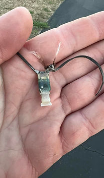
Geolocators are lightweight devices that can be deployed on species as a mode of tracking movements. Rather than the device collecting coordinates, the device collects light information for roughly one year. This light information, with some coding, can be transformed to location/coordinate information. In order to retrieve the data, however, we must retrieve the unit.
What are ARUs?
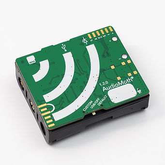
ARUs or Automated Recording Units are a type of technology which records flight calls of birds. These calls can me inputed into Machine Learning program which helps to identifiying the numbers and species flying overhead.

Automated Telemetry - MOTUS Wildlife Tracking Network
One of the other ways we can monitor birds is using automated telemetry such a Motus. We can deploy antennas which have a coverage for a certain amount of area. Only signals and tags with a specific band width when in range will ping the tower and the data will automatically be uploaded.
Expanding the motus tracking network to Alabama:
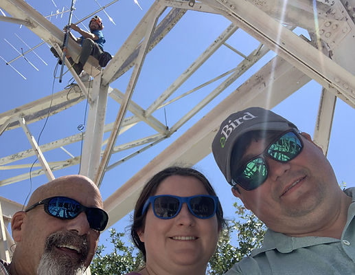
We set to deploy Coastal Alabama's first Motus Tower in August 2023 in partnership with Dr. Orin Robinson (Cornell University) and the Dauphin Island Sea Lab. We hope to help expand the Motus network even more as funding and time allows! For more information about motus, go here.


Biometrics & DNA Sampling
In order to answer our important conservation questions, we also collect standard banding measurements like wing and tail length. We also bird health data by determining the "body condition" of the birds. We calculate this by collecting bird weight and blowing on the chest feathers of the bird to examining how much fat and muscle the birds have. This is what is referred to as fat and muscle scores which is done simply by observing the keel of the bird by blowing apart the feathers and giving it a subjective score based on what is observed.

.jpg)
Example (top right) of looking at fat and muscle scoring. The feathers are gently blown on the expose the breast/keel of the bird to observe the flight muscle and fat. Left is an example of measuring the tail length of a bird.

Additionally, we are authorized to collect feathers, primarily tail feathers. We typically collect 1-2 tail feathers from one individual. The reason we do this is because the feather holds valuable information mainly in the form of DNA. We also sometimes collect a small blood sample from a bird by using a small needle to access the brachial vein on the wing. This procedure is akin to a person having their blood drawn except we take a very small amount (1% or less of the bird's body weight). We follow all standard procedures on this and decades of research reveal no impacts to birds.

Example of brachial bleed on an American Kestrel. A sterilized needle is used to gently puncture the brachial vein to collect the small amount of blood in a sterile sample tube.


One of the main collaborators we work with is the Bird Genoscape Project (BGP). The blood and feather samples we contribute help to create genoscapes, which are maps of genetic variation across species’ ranges. This method developed by the BGP can be used as a tool for conservation, as it allows us to better understand how populations are connected across their full annual cycle. Special thanks to BGP staff member Amanda Carpenter who is a BCA banding volunteer and liaison between our organizations. Above is an example of BCA feather samples being curated at the BGP.


